In modern architecture, precision is no longer a luxury — it’s a necessity. As architects and designers push the boundaries of innovation, technologies like (Light Detection and Ranging) have become indispensable. Whether capturing complex building geometries or generating 3D models of existing structures, LiDAR is transforming how architectural projects are planned, visualized, and executed.
This blog explores the meaning of LiDAR, how it works, its role in architectural mapping, and the system architecture behind this powerful technology shaping the future of design.
What is LiDAR?

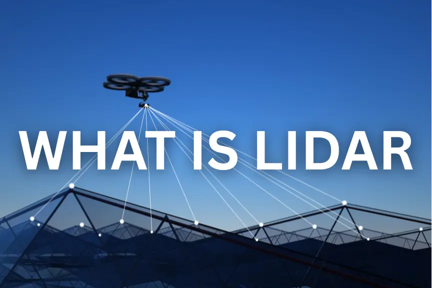
LiDAR stands for Light Detection and Ranging — a remote sensing technology that measures distance using pulses of laser light. It works by emitting rapid laser signals toward a surface and measuring how long it takes for each pulse to return to the sensor. The result is a highly detailed, three-dimensional dataset known as a point cloud.
Each point in this cloud represents an exact coordinate in space — allowing architects to visualize, measure, and model physical environments with millimeter-level accuracy. Unlike traditional measurement techniques that rely on manual input or photographs, LiDAR provides real-world precision — enabling faster, more efficient architectural surveys, even in complex or inaccessible spaces.
LiDAR Meaning in Architecture
In architectural terms, LiDAR is a digital design and documentation tool that bridges the gap between the physical and virtual world. It captures the real-world geometry of existing buildings, landscapes, and structures to create accurate 3D representations used for :
- Site analysis and design planning
- Renovation and restoration projects
- BIM (Building Information Modeling) integration
- Historic building documentation
- Urban infrastructure modeling
For architects, LiDAR’s meaning goes beyond data — it’s about design precision, spatial awareness, and informed decision-making. By translating real-world conditions into digital form, LiDAR empowers designers to plan with confidence, avoid errors, and optimize every design phase.
How LiDAR Works
At its core, LiDAR relies on a simple yet highly effective principle: measuring the time it takes for light to travel to an object and back.
Here’s how it works in the architectural context:
| Laser Emission | The LiDAR device emits thousands of laser pulses per second toward the target environment — walls, ceilings, landscapes, or structures. |
| Reflection Detection | The laser bounces back to the sensor after hitting a surface. |
| Distance Measurement | The system calculates the distance based on how long the light took to return. |
| Data Generation | Millions of these measurements are combined to create a 3D point cloud, a digital model of the environment. |
| Processing | Specialized software refines the point cloud into architectural models compatible with AutoCAD, Revit, or BIM platforms. |
The result: a highly accurate digital twin of a building or space, allowing architects to analyze every angle and detail before making design decisions.
Mapping in Architecture
Mapping is one of the most valuable applications of the technology in architecture. It involves creating 3D maps and models of buildings, terrain, and environments using data.
These maps are vital for:
- Site evaluation and feasibility studies: LiDAR maps help architects assess topography, elevation, and landscape challenges before construction begins.
- Urban planning and design: City planners use data to map infrastructure, analyze building heights, and plan sustainable layouts.
- Historic preservation: LiDAR mapping captures intricate details of heritage structures for restoration and digital archiving.
- Renovation and remodeling: LiDAR scans existing structures to provide as-built models, ensuring that new designs align perfectly with existing conditions.
By turning millions of laser data points into usable 3D models, LiDAR mapping eliminates guesswork and accelerates decision-making — enabling smarter, more sustainable designs.
System Architecture
The architecture of a LiDAR system is the foundation of its precision. It combines optical, mechanical, and computational components that work seamlessly to capture and process 3D spatial data.
Here’s a breakdown of its core elements:
1. Laser Transmitter (Emitter)
Generates high-frequency laser pulses directed toward the target surfaces. The type of laser determines range and resolution.
2. Receiver (Optical Sensor)
Captures reflected light and measures the return time to determine distance accurately.
3. Scanning Mechanism
Controls the direction of laser pulses — either via rotating mirrors or solid-state scanning — to capture complete 3D coverage of the structure.
4. Positioning and Orientation System (GPS + IMU)
Ensures every point of data is accurately georeferenced, maintaining spatial consistency during scans.
5. Processing and Storage Unit
Converts raw LiDAR data into point clouds and integrates it with modeling software like BIM or CAD, enabling real-time visualization and analysis.
Together, these components form a precise, data-rich system that powers every architectural LiDAR scan — from indoor measurements to large-scale urban mapping.
Benefits of LiDAR in Architecture
- Unmatched Accuracy: Provides exact measurements, reducing design errors.
- Time Efficiency: Large projects can be scanned in hours instead of days.
- Comprehensive Data: Captures complete spatial geometry, even of complex structures.
- Enhanced Collaboration: data integrates with BIM for seamless coordination.
- Supports Sustainability: Reduces material waste by enabling precise planning.
Architectural firms across the U.S. are leveraging LiDAR to create data-driven, future-ready designs — improving accuracy while cutting costs and time.
Conclusion
As the architectural landscape embraces digital transformation, LiDAR has emerged as one of the most powerful tools in the designer’s toolkit. It bridges creativity with technology — capturing the real world in precise digital form to enhance every stage of the design and construction process.
From LiDAR mapping and 3D scanning to system architecture and BIM integration, this technology is shaping the future of how architects design, document, and build.
In short, LiDAR isn’t just redefining measurement — it’s redefining architecture itself.


