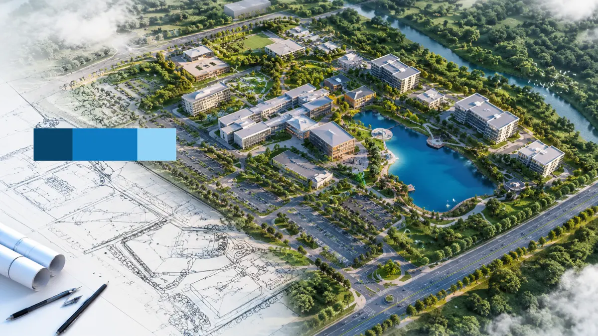
A site plan typically encompasses numerous buildings, streets, and other site elements and is often quite large and complicated. People unfamiliar with site plans may struggle to recognize the relationships and functions among all the elements. Aerial 3D rendering lets planning and design personnel quickly evaluate and understand complex site plans.
The bird’s-eye view is an integral part of 3D site plan rendering services, including the location and relationship of the various land uses and movement ways. A well-balanced master plan rendering suggests the plan’s relationship to its surrounding environment. A site plan should not be intended solely to illustrate the location of a structure or a facility; if it is, the site plan is basically a graphic failure. A site plan should also illustrate the movement of vehicles and people. It should also indicate the location of public and private open spaces, and other facilities.
When creating aerial views of master plans at McLine Studios, we are often asked, “What should be shown?” When creating a 3D visualization, either as part of a 3D master plan or as a master plan visualization for a review board, investor meeting, or sales center, keep the following in mind. A master plan visualization can be considered a communication tool, and as such, there are many options available to the designer to best illustrate the plan. An aerial site visualization can also be considered a marketing tool; however, this should not drive the communication decisions made by the designer.
What Is Aerial 3D Rendering for a Master Plan?
An image taken from the ground shows the view of a project as it is being constructed. This image can show some aspects of the project, such as materials and the human scale of the project, but it cannot show the entire project. Some parts of the project may be too large to be shown in one image taken from the ground. Aerial rendering services can help give a different view of the project. An aerial view shows the context of the project, the public road system, the project, and other adjacent projects.
Why the Bird’s-Eye Perspective Matters
High viewpoints help explain design rationale. Depending on the vantage point, people can read different things about the plan, like where the main entrance is or how far residents need to walk to use the provided facilities. Bird’s-eye view renderings help integrate design team members (architects, owners, and review agencies) located in different places and time zones. It synthesizes the different drawings and helps explain design ideas. Users of 3D site plan rendering services already understand the benefits of moving from 2D plans to 3D plans. For design teams, the benefits of using bird’s-eye view renderings for their integration and design ideas are apparent. The renders help illustrate the built and unbuilt elements of the design.
10 Things to Show in a Bird’s-Eye Master Plan Rendering
Each of the elements of a master plan varies, but the following ten elements tend to capture what reviewers, investors, and buyers are looking for.
- Building Massing and Placement
Show accurate footprints, heights, and spacing of structures in a plan. This allows review boards to analyze proposed development in relation to surrounding land use. Clear building massing helps a review board assess the overall scale and proposed intensity of development. Massing helps a developer evaluate potential landing patterns of buildings in a plan. In a master plan rendering, facade detailing is best reserved for close-up views.
- Roads, Drives and Internal Circulation
Circulation is typically one of the first elements of a plan that stakeholders review. Showing different classes of roads and routes in a plan helps visualize the hierarchy. Roads and circulation are usually depicted in plans in a side or perspective view. The treatment of roads in a site plan visualizes what a development’s traffic might look like. Incorporating differences in road and pavement widths in plan helps to visually depict differences in roadways.
- Parking and Access Points
Parking is something that is often easy to omit in architectural designs. It is also something easy to criticize. Make sure to include all kinds of parking, from resident to visitor parking, to service access, to drop-off zones, to loading docks. Oftentimes, parking is shown in plans to demonstrate its footprint on a site, and especially in parking in 3D site plan renderings, to relate it to the site’s buildings. Placing a select few cars in a design demonstrates its functionality and capacity, and helps potential reviewers understand the design.
- Landscape and Green Spaces
Elements like parks, gardens, tree, and shrubbery-lined pathways, and buffered green spaces help shape the character of a development and define edges, screen views, and assist in management of surface runoff. Erosion and sedimentation. While it is sometimes necessary to show the level of detail in a landscape in aerial rendering, other times less detail can be shown to create an effective rendering, especially when imagining a development as a built environment. This is where master plan visualization starts to feel like a real place instead of a diagram.
- Amenities and Shared Spaces
Master plans show buyers and investors what a development has to offer. Including amenities helps answer that question. Including amenities in master plan visualization makes a development more appealing. Potential buyers and investors want to know what they are paying for, so showing pools, playgrounds, clubhouses, plazas, and recreation areas is a good way to gain and maintain interest in a development. A dedicated 3D exterior rendering service can support the hero structures inside a larger aerial scene.
- Site Boundaries and Surrounding Context
A project has to account for a multitude of factors outside of its scope. A good design accounts for site context visualization in an efficient manner. It helps create a sense of place rather than a design that appears to be plopped down in an arbitrary location. Aerial architectural renderings for planning boards tend to focus on the proposed project rather than surrounding context. However, it helps to be familiar with the surrounding context so that you can answer potential questions and draw relationships with the proposed project. It shows a design team is capable of working within existing patterns and relationships.
- Terrain, Elevation and Topography
Site topography, such as changes in elevation, slopes, and water features, limits where buildings and infrastructure can be placed and where drainage ways can be located. Using topography in aerial site visualization allows for showing features like retaining walls, viewing corridors, and other building location constraints. Even minor elevation changes can impact how a site is accessed. A 3D site plan at an appropriate scale in perspective would more accurately and completely illustrate a site compared to a site plan at an appropriate scale in an orthogonal view. A slightly lower camera elevation in perspective illustrates grade changes and involves less distortion than an extremely high camera elevation.
- Open Space and Pedestrian Connections
Walkable networks connect the various features of a project and provide residents with different ways to travel on foot. In a master plan rendering, routes that connect destinations and demonstrate various ways residents can travel by showing where they can gather, rest, and play. Often, landscape rendering services work in conjunction with architects to demonstrate the design of public realm spaces, especially if the public realm is of greater importance to the overall project. Public spaces should be designed to facilitate different activities. In design, it is important to keep different routes for different modes of travel to facilitate their functions.
- Development Phases
Financing, approvals, and sales for a development are typically spread out over several years. Use phasing to show different stages of a project in plans, elevations, and perspectives. Use different colors to represent stages of the project. The main purpose of phasing in master plan visualization is to allow city officials and prospective investors to visualize the completed project. This is often complicated by the need to include the existing conditions on the project site to facilitate an understanding of the planned improvements.
- Scale, Orientation and Visual Hierarchy
North arrows and known landmarks can help establish orientation. Including a scale and using hierarchy through color and contrast to create focal points can help the viewer locate information more quickly and easily. If every item competes for attention, the aerial rendering loses its message. It is important to establish the goal and message of the image, and to then create related supportive information.
How Much Detail Should an Aerial Master Plan Rendering Show?
Detail should be appropriate to the purpose of the rendering. This means that different renderings may contain different levels of detail. More detail isn’t always better. In fact, sometimes less detail may be more effective. The amount of detail used in a rendering depends on the experience level and expertise of the person who will make the decision based on the rendering.
- Planning Presentation: Preliminary design rendering focusing on circulation and site relationship to the surrounding context, with limited site landscape treatment.
- Investor Presentation: Design rendering focusing on site development at various phases and site context to illustrate site development opportunity.
- Marketing: Rendering focusing on site development and landscape treatment to illustrate potential site use and function.
- Design Review: Massing of the various elements of the site and building relationships to the site to assist the plan review team.
This is where aerial rendering for real estate development really excels. When a brief includes large-scale, integrated development, provide as much detail as you can for the larger component parcels and integrate hero elements for the smaller parcels. Real estate development visualization is often used by firms in a number of different markets and situations. It’s not uncommon for a team to create two or three views from the same model based on the audience for each. A buyer and a planner are not the same audience.
|
|
View | Primary Purpose |
Top-down site plan | Precise layout and spatial organization |
Bird’s-eye view | Overall development understanding |
Elevated aerial view | Buildings, site and surrounding context together |
Ground-level rendering | Architectural appearance and human experience
|
|
|
View | Primary Purpose |
| Top-down site plan | Precise layout and spatial organization |
| Bird’s-eye view | Overall development understanding |
| Elevated aerial view | Buildings, site and surrounding context together |
| Ground-level rendering | Architectural appearance and human experience |
View | Primary Purpose |
| Top-down site plan | Precise layout and spatial organization |
| Bird’s-eye view | Overall development understanding |
| Elevated aerial view | Buildings, site and surrounding context together |
| Ground-level rendering | Architectural appearance and human experience |
Ground-level rendering | Architectural appearance and human experience |
A top-down 3D site plan rendering aligns and dimensions horizontally on the plan. An aerial view shows how the parcels integrate with the surrounding environment. For aerial 3D visualization, the environment can be articulated at many levels and from many locations. Some project participants, like the architect, may focus primarily on the plan. Others, like the developer, may focus on the integrated project and the opportunity in the surrounding environment.
Aerial 3D Rendering for Different Types of Master Plans
Master-planned communities are made up of multiple components. The placement of roads and green spaces affects how buyers perceive community design. Strong 3D renderings for master-planned communities demonstrate how building phases roll out over time. Buyers consider connectivity and how friendly a community is to walking and outdoor recreation.
Many factors related to design and development impact commercial development and financing. These might include, but are not limited to, site access, circulation, landscape, surrounding development, building massing, and parking. Rendering services can help clarify site elements and trade. Commercial rendering services may also help clarify design elements of proposals for retail centers, office parks, and campuses. This may help 3D development visualization to support leasing and approval conversations, and facilitate approvals and leasing.
Integrating different land uses requires balancing separation and connection of various zones (i.e., residential, commercial, public, services, and open spaces) in a master plan rendering. An effective representation of a master plan shows varying uses of land and illustrates the arrangement of buildings and spaces. It demonstrates the location of first-floor commercial/retail uses and the entrance to residential uses.
Urban and large-scale development. Public and major landscape realms. Priority development categories inform and guide the design of a framework to accommodate flexible urban design responses. Aerial visualizations for urban planning should depict the surrounding city to help assess the relationship to adjacent urban fabric, public realm, and transportation.
What Information Is Needed to Create an Aerial Master Plan Rendering?
The more information we have, the better the results will be. Examples of information we request include:
- CAD or site plan drawings
- Architectural plans
- Survey information
- Models
- Landscape plans
- Contour data
- Context information
- References
- Photos
- Information concerning perspective and view requirements.
Not all information is needed at the beginning. Visualization can start with site plans or massing models, and become more refined with the advancement of the project. The quality of 3D site plan rendering and aerial site visualization is dependent on the clarity of survey and topographic data, along with any image requirements. It is ideal to obtain survey and topographic data as early in the process as possible, along with any image requirements.
Common Mistakes in Aerial Master Plan Rendering
- Including too much detail. Adding too many features (trees, cars, people, etc.) detracts from the message of the plan.
- Using the wrong camera angle. An aerial view that does not show the relationships of the plan is not helpful.
- Failing to consider surrounding elements. Relationships to the surrounding environment are extremely important to understanding the site.
- Using elements in an unorganized manner. Each element of the plan should not be of equal importance.
Misrepresenting the plan. Just because the master plan visualization needs to be easy to understand for a wide audience does not mean aspects of the plan can be modified to suit the vision of the planner. Exaggerating or modifying aspects of the plan can damage the planner’s credibility quickly.
How McLine Studios Approaches Aerial 3D Rendering for Master Plans
Mcline Studios incorporates architectural and site-related information at various scales. We address context and presentation. We can provide Aerial 3D Rendering services for proposed projects. We will make the final image easy to understand for your target audience.
We are available to consult at any stage and enjoy discussing your goals for camera positioning and usage. We can create compelling images using the construction documents and other project information created by members of your design team.